The landscape along Lake Michigan on Chicago’s South Side has utterly changed over the past century. If you’re looking for the beaches where Chicago’s race riot erupted on July 27, 1919, you won’t find them.
As I was researching a history of the riot for Chicago magazine, I searched for maps, documents, and details that would explain where these events took place—and what is there today.
It may never be possible to pinpoint precisely where a black 17-year-old named Eugene Williams drowned in the lake’s waters after a white man threw rocks at him, but maps do show where the shoreline was in 1919—farther west than where it is today.
When you walk along the lake today—south of McCormick Place and north of 31st Street’s Margaret T. Burroughs Beach—look over toward Lake Shore Drive. Imagine that the shoreline was over on the other side of the road. The spot where you’re walking was part of Lake Michigan back then.

Two beaches played a role in the events of 1919: one that was supposedly for white people only, and one that was used mostly by African Americans.
There was no law enforcing the racial segregation of these beaches, but black Chicagoans of that time said they knew they’d be attacked if they encroached the territory claimed by white racists.
The beach dominated by white people was usually called the 29th Street beach—located around the spot where 29th Street would hit the shoreline if the street extended that far east. The beach was just east of Michael Reese Hospital.
The beach used by black people was a few blocks north of the white area. It was usually—but not always—called the 26th Street beach.
In its verdict on the death of Eugene Williams, the Cook County coroner’s jury said that the blacks’ beach was at 22nd Street:
“We find that the beaches on the lake front in south division of the City of Chicago have heretofore been used by white and colored people, but by common consent, segregated, the colored people using a beach at the foot of 22nd street, the white people using the beach at the foot of 29th street and at points further south. While there may have been some friction in the use of the beaches nothing of moment occurred until the afternoon of July 27th, 1919.”
The reference to 22nd Street seems to be an error. That location isn’t corroborated by other historical references.

The Chicago Commission on Race Relations’ extensive report about the riot called it the 26th Street beach—but one passage in the book describes it as being near 27th Street. At another point, the book says that the beach was at 28th Street.
In the months leading up the riot, two weekly black newspapers, the Chicago Whip and the Chicago Defender, both called it the 26th Street beach.

One of the teenagers who was with Williams on that fateful day at the beach, John Turner Harris, described the beach when he spoke a half-century later with author William M. Tuttle Jr. Tuttle asked: “This is 26th Street?” Harris replied:
“This is actually the 25th Street beach. … Actually, there is a big sign naming this the 25th Street beach.”
These beaches were informally organized. The Chicago Commission on Race Relations reported that the beaches were not “publicly maintained and supervised for bathing,” and yet they were “much used.”
According to the Whip and the Defender, a man named Max Olmstein or Olenstein managed the 26th Street beach that was frequented by black Chicagoans. According to the 1920 census, this was apparently a 64-year-old immigrant from Germany who worked as a manager of a collection department. The Whip reported that he’d hired five lifeguards for the beach.
“Mr. Max Olenstein, we hope you keep up the good work for the second ward, as well all know you have a good crew of Life Guards,” the Whip commented. Addressing its black readers, the newspaper said:
“Come any time you want, there is always some one down there to protect you at the Beach from 5:30 A.M. to 9:30 P.M.”
Eight days later, Eugene Williams drowned at the beach and a riot broke out.

In his interview for Tuttle’s 1970 book Race Riot: Chicago in the Red Summer of 1919, John Turner Harris described the trip he took with Williams and three other friends to the beach on that day. Tuttle shared his interview transcript with me, including details that weren’t published in his book.
After riding north up Wabash Avenue on the back of a produce truck, Harris and his friends got off at 26th Street and walked east. At the end of the street, they headed north for one block, walking past a police station and a fire station. The teens then went east on 25th Street. Harris remembered walking near the Hydrox Ice Cream Company’s factory.

The Hydrox factory is not on the Sanborn Fire Insurance Map from 1911, but later documents show that it was north of 25th Street along Lake Park Avenue. On April 18, 1919, the Chicago Tribune reported that Hydrox was planning to construct one of the country’s largest ice-cream and soft-drink factories at the site.

As they continued east, Harris, Williams, and their friends reached the Illinois Central Railroad tracks. “We went over the bridge where the Illinois Central track is to the beach,” Harris recalled. The 1911 Sanborn map shows one bridge across the tracks, roughly a block south of 25th Street.

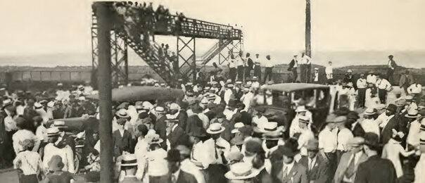
According to the Chicago Commission on Race Relations’ book, The Negro in Chicago:
“The approach is over a rough road through a much-neglected neighborhood, and then up a long flight of stairs to a four-foot viaduct over the railroad tracks, and a roundhouse and switch yards are near by.”

That book also includes a photo showing a bridge over the tracks, with a caption identifying it as the 29th Street beach. Is it the same bridge Harris mentioned—the one that appears on the 1911 map? Or was there another bridge farther south?
Here’s how The Negro in Chicago describes the 26th Street area of the shore:
“The beach is a strip of sand about fifty feet wide and a short block in length; it narrows at one end to the tracks and at the other end is walled by a high embankment. While it offers a chance to get into the lake, the atmosphere of wholesome, recreative outdoor life is entirely lacking.”
The South Park Commission—which was later folded into the Chicago Park District—had surveyed the shoreline here in 1907.

This section of the lakefront looks similar in a U.S. Army Corps of Engineers map from 1918:

And it was largely unchanged in an Army Corps map four years later:

Harris said that he and his friends went to a place on the lakefront a bit south of the beach used by blacks. He believed that it was near 26th Street. These maps suggest that he may have been talking about the area with a small inlet—about halfway between 26th and 27th Streets.
Harris and his pals had a nickname for this spot: “hot and cold.” This was where an ice factory and breweries poured a mix of hot and cold fluids into the lake.

Harris remembered an ice factory run by the Consumers Company. The 1911 map shows the Hygienic Ice Company at 2553 South Park Avenue, but Consumers was operating an ice plant at the same location by 1923.

Harris recalled the Keeley Brewing Company’s plant dumping its water into the lake. In fact, there were two breweries flanking 27th Street: Keeley and Conrad Seipp Brewing Company.
With the advent of Prohibition, the Seipp brewery had recently switched to making “near beer,” with a legally permissible alcoholic content of half a percent. The Chicago Tribune remarked:
“No longer will the smell of hops permeate the air in that district of Chicago adjacent to Lake Michigan from Twenty-fourth street south to Twenty-eighth.”
(According to the Encyclopedia of Chicago, “Many speculated that Seipp also produced bootleg beer for the Torrio-Capone crime organization.”)


Harris said that he and his friends went to a “little island,” where they’d built a raft. No islands appear on the maps, but that may simply be because they aren’t detailed enough.
Harris described the route they took with their raft: “We were going in an angle from the 25th Street beach to a given point—there was a little pole out there with a milepost.” Then they approached a breakwater.
“This breakwater on 26th Street went all the way through in the rocks. … This breakwater was all the way out there and the shore is irregular.”

The Army Corps of Engineers map from 1918 shows a spot slightly north of 28th Street where the land juts out—roughly 88 feet, according to the map’s scale. This spot looks like the closest match to the breakwater described by Harris. Was this outcropping also the demarcation for that invisible line through the water, the boundary that blacks weren’t supposed to cross?
According to Tuttle’s book: “Passing by the breakwater near 26th Street, the youths noticed a white man.” Harris said that a white man who was “walking along the breakwater” threw rocks at them. Harris estimated that the man was 75 to 100 feet away from the teenagers and their raft.
It seems likely that Eugene Williams died somewhere in the water east of that spot where the land jutted out into the lake. “We were in about 15 feet of water at the time,” Harris recalled. The Army Corps of Engineers map shows depths of 9 feet and 10.25 feet in nearby water.
Measuring the endpoint of that breakwater on the 1918 Army Corps of Engineers map, I estimate that the latitude and longitude are 41.84378,-87.61168. Plugging those coordinates into Google maps, the point is shown in a parking lot just east of Lake Shore Drive. The area where Eugene Williams died in the water would have been roughly 75 to 100 feet from there—around where Moe Drive is today, or perhaps on the western edge of Lake Shore Drive.

Eugene Williams’s death certificate (in the records of the Cook County clerk’s office) lists the location of his death as “Lake Michigan at 29th St.” That might indicate that’s where his body was brought ashore. Or it could be just a general indication of the area where he died. Or is it intended to be a specific location—indicating that the spot of his death was at 2900 South?

The Cook County grand jury indictment of a white man accused of throwing rocks at Williams—George Stauber, who was later found not guilty—does not include a specific location for the death, other than “the waters of Lake Michigan.”

* * *
This area is not the only place where Chicago’s lakefront has evolved beyond recognition. All up and down the shoreline, landfill was added, moving the water’s edge toward the east. The Encyclopedia of Chicago features a map by Dennis McClendon showing how landfill changed the shoreline. (McClendon also runs the useful Chicago in Maps website.)
In the area near the old 26th and 29th Street beaches, the land was extended in the early 1930s—creating part of the fairgrounds for A Century of Progress International Exposition, the world’s fair that Chicago hosted in 1933 and 1934.

Above, a 1924 South Park Commission plan shows the old shoreline and a planned breakwater to the east. By 1929, that breakwater appears on a U.S. Geological Survey map:

That space between the shoreline and the breakwater was filled in by 1933. Below, a Conoco Travel Bureau map of the fairgrounds shows the Midway attractions on the newly created land just east of where the beaches used to be—including carnival rides, replicas of historic scenes—and some features that sound horrifying, including a “Negro Plantation Show.”

In the decades after 1919, Michael Reese Hospital expanded, taking over the land where the breweries had been.


The hospital shut down in 2009, and the buildings were demolished, leaving the desolate vacant land of today. The site was touted as a possible location for the Olympics, when Chicago bid (unsuccessfully) for the 2016 Games. In 2019, Mayor Lori Lightfoot suggested it as one of several possible sites for Chicago’s first casino.
The land east of Lake Shore Drive—where the 1933-34 world’s fair Midway entertained visitors—is now part of Burnham Park, a 653.6-acre expanse of beaches, trails, green space, and natural areas along the South Side’s lakefront that is owned and maintained by the Chicago Park District.

A boulder with a plaque commemorating the 1919 race riot sits along a trail just west of the lake, around where 29th Street would hit the lakefront if the street continued east of Lake Shore Drive.

It appears to be around 500 feet southeast of the vicinity where Eugene Williams died—but given how much the surrounding scene has transformed over time, it may be as appropriate a place as any to place a marker for this tragic event.

Burnham Park is named, of course, after architect and urban planner Daniel H. Burnham, who cowrote the famous 1909 Plan of Chicago with Edward H. Bennett. Burnham and Bennett called for the creation of park space all along the lakefront, influencing the later decisions of city and park officials. Today’s lakefront is beautiful, though it doesn’t quite match the vision that Burnham and Bennett had. Their book includes this painting of their planned lakefront by Jules Guerin:

They envisioned a sequence of lagoons and harbors along the lakefront. Northerly Island is one piece of their plan to create a man-made series of “islands” along the shore. Here is a close-up of Burnham and Bennett’s plan for the shore around those old beaches at 26th and 29th Streets:

Burnham and Bennett waxed rhapsodic about the importance of Lake Michigan to the city of Chicago and its people—words worth meditating on as we remember the race riot that broke out on the lakefront in 1919:
“The opportunities for large parks in the immediate vicinity of Chicago are ample. First in importance is the shore of Lake Michigan, which should be treated as park space to the greatest possible extent.
“The Lake front by right belongs to the people. It affords their one great unobstructed view, stretching away to the horizon, where water and clouds seem to meet. No mountains or high hills enable us to look over broad expanses of the earth’s surface; and perforce we must come even to the margin of the Lake for such a survey of nature. These views of a broad expanse are helpful alike to mind and body. They beget calm thoughts and feelings, and afford escape from the petty things of life.
“Mere breadth of view, however, is not all. The Lake is living water, ever in motion, and ever changing in color and in the form of its waves. Across its surface comes the broad pathway of light made by the rising sun; it mirrors the ever-changing forms of the clouds, and it is illumined by the glow of the evening sky. Its colors vary with the shadows that play upon it. In its every aspect it is a living thing, delighting man’s eye and refreshing his spirit.
“Not a foot of its shores should be appropriated by individuals to the exclusion of the people. On the contrary, everything possible should be done to enhance its attractiveness and to develop its natural beauties, thus fitting it for the part it has to play in the life of the whole city. It should be made so alluring that it will become the fixed habit of the people to seek its restful presence at every opportunity. “